Help
Howdy, and welcome to iNaturalist! This page served as iNaturalist's FAQ page until January 11th, 2024. Official iNaturalist FAQs are now posted on the iNaturalist Help site, as well as some how-tos, as part of our migration of help documents to a new platform. This page will still exist for the time being and is editable by iNaturalist Curators, but it may be out of date.
If you're just getting started with iNat, check out the Getting Started guide to tour some of the site's features. If you have a question about the site, please peruse the FAQ below. If you're still looking for answers, make a Support Ticket here or post your question to our Community Forum.
Frequently Asked Questions
General
- What is iNaturalist?
- Who is behind iNaturalist?
- What technologies and data sources does the project use?
- What can I do to help iNaturalist?
- How do I contact iNaturalist?
- What are staff, curators, and site admins?
- What is the difference between iNaturalist and Seek?
- What is considered inappropriate content?
- Spam! What do I do about it?
- Can I use the photos that are posted on iNaturalist?
- Will you remove observations from my private property?
- Can I use the iNaturalist logo when linking to iNaturalist?
- Why doesn't the blog widget work very well?
Observations
- What is an observation?
- What kind of photos and sounds should I attach to observations?
- Are observations required to have photos?
- Can I add multiple taxa per observation? What if my photo has a flower AND a cool bug?
- What does captive / cultivated mean?
- How can I get help identifying what I saw?
- Why doesn't iNaturalist recognize the name I've entered?
- What is the data quality assessment and how do observations qualify to become "research" grade?
- What is geoprivacy? What does it mean for an observation to be obscured?
- How do I add sounds?
- Can I upload videos to iNaturalist?
- What are tags, observation fields, and annotations?
- What does it mean to link iNaturalist to my Flickr account?
- Why is my observation not showing up in a Place or Collection project? I know I observed it there.
- Can I upload my old photos as observations?
- What do the map symbols mean?
- Why can't I add observations of rocks or litter? They're part of nature and affect wildlife.
- Why is my observation's location name incorrect?
- Why is "iNaturalist" voting that my observation is not "wild"?
Identifications
- What is an identification?
- When should I agree with someone else's identification?
- What if I disagree with someone's identification?
- I identified my observation after someone else added a higher-level ID, so why is the observation stuck with the higher level ID?
- Why do people keep adding "obvious" IDs like "Plants" or "Fungi"?
- I don’t agree with iNaturalist’s taxonomy. Do I have to follow it when I add an ID?
- I posted an observation a few days ago but no one has Identified it yet. Am I doing something wrong?
- What does it mean to mark an observation as "Reviewed"?
- What if an observation has photos or sounds of multiple different species, like birds, lizards, and flowers?
- What should I do about "duplicate" observations?
Taxa (e.g. Genera, Species, Common Names)
- How do I add a missing species to the iNaturalist database?
- Can I add common names?
- Why don’t I see my expected common name?
- Something is wrong with the taxonomy, a species name, or common name. How does this get fixed?
- The taxon photo is wrong. How does this get fixed?
- What guidelines should I follow when choosing taxon photos?
- A species should be marked as present/absent or native/introduced in a certain place. How does this get fixed?
- Is there anything more than animals, plants, and fungi? What are all the kingdoms of life?
Computer Vision
- What is computer vision?
- Which taxa are included in the computer vision suggestions?
- Why can't computer vision identify my photo correctly?
- How can I tell if someone selected a computer vision suggestion?
- What does "Expected Nearby" mean?
Science and Research
- How is iNaturalist data used for research?
- How can I download data from iNaturalist?
- I am a researcher or working for a governmental agency. How can I access the hidden coordinates of sensitive species?
- How should I cite iNaturalist?
- Which iNaturalist observations are exported for GBIF, and how often does this export happen?
- If an observation’s ID or data quality grade changes, will that change be updated on GBIF?
- What other entities use iNat data exports?
Lists
Projects
- What are projects?
- How do I restrict project contributions to a geographic area?
- How do I restrict project contributions to a geographic area that isn't already in the database?
- Why can't I add my observation to this project?
- This observation meets the project requirements, why isn't there a link to the project on the observation itself?
- Why won't some observations appear in my place-based collection project? I know I observed them there.
- Can I get around the 50 verifiable observations limit for creating a place or a traditional project?
- Why do species counts for my umbrella project and its subprojects differ?
Guides
General
-
What is iNaturalist?
iNaturalist provides a place to record and organize nature findings, meet other nature enthusiasts, and learn about the natural world. It encourages the participation of a wide variety of nature enthusiasts, including, but not exclusive to, hikers, hunters, birders, beach combers, mushroom foragers, park rangers, ecologists, and fishermen. Through connecting these different perceptions and expertise of the natural world, iNaturalist hopes to create extensive community awareness of local biodiversity and promote further exploration of local environments.
iNaturalist is an independent 501(c)3 nonprofit based in the United States (EIN 92-1296468).
-
Who is behind iNaturalist?
iNaturalist was originally the Master's Final Project of Nathan Agrin, Jessica Kline, and Ken-ichi Ueda at UC Berkeley's School of Information. Check out the Team page for more info on the current staff members.
-
What technologies and data sources does the project use?
The central iNaturalist database is PostgreSQL, with heavy reliance on elasticsearch for search. The web application is built using the Ruby on Rails framework, and our API is built around Express. Our web frontend is a mix of plain Rails views and React for more interactive views.
The iNaturalist iPhone and Android apps are both developed using native tools for their respective platforms. Seek is built with React Native.
Most useful data on iNaturalist is provided by users. Maps and geocoding services come from Google Maps, except in the iPhone app where they are from Apple Maps. We utilize Flickr and Wikimedia Commons as sources for some images used on taxon pages, as well as the Catalogue of Life, uBio, and a variety of other data sources to import taxonomic information. For a list of taxonomic authorities and policies, see the Curator Guide. Many of the geopolitical boundaries we use originally came from GADM.
-
What can I do to help iNaturalist?
First and foremost, you can be an active member of the community by adding your observations and helping other community members identify their unidentified observations. You can also help by sharing your ideas and feedback. Join our Community Forum to interact with other users, report bugs, and request new features. If you know how to code and want to help work on some features, fork us on GitHub! You can donate to support iNaturalist. There's even more ways to help out, explained on the iNaturalist Community Forum.
-
How do I contact iNaturalist?
You can contact us at help@inaturalist.org.
-
What are staff, curators and site admins?
iNat staff are the people who run the site. They have direct access to the underlying code and the database, and they can change anything on the site. You can read more about the staff members here.
Curators are iNat users who volunteer to help keep our taxonomic data up to date and help deal with other issues. This is not the same thing as a project curator. If you are interested in becoming a curator, read through the iNaturalist Curator Guide in full then fill out the Curator Application. In order to apply to be a site curator you must have had an account for 60 days or more, have added 100 improving identifications to anyone's observations, including your own, and have made at least five flags. More info about curators and their roles can be found in the Curator Guide.
The fact that someone is a Curator does not necessarily mean they have taxonomic or identification expertise.
Site Admins help administer national nodes in the iNaturalist Network including how those nodes are configured etc.
-
What is the difference between iNaturalist and Seek?
iNaturalist (app and website) Seek (app) iNaturalist is an online community that allows you to share observations to discuss, identify, and create research-quality citizen science data for science and conservation. Seek allows curious naturalists of all ages to earn badges and participate in challenges to observe organisms with on-screen identification using computer vision for identifications based on data from iNaturalist. Best choice if you want to connect with others, share data, and are interested in natural history and contributing to citizen science Best choice if you do not want to create an account or share data, or are just getting started exploring nature Users must be 13 or older to make an account No login or account required, kidsafe. Users aged 13+ or with parent’s permission can optionally log in with their iNaturalist account and post observations to iNaturalist through Seek iNaturalist’s identification model provides initial suggestions, but other people in the iNaturalist community help you identify and confirm your observations Seek’s identification model provides an identification in real-time on screen Records observations as biodiversity data that contribute to citizen science This identification does not leave your device or require an internet connection to work Photo, location, and time are recorded with each of your observations in the iNaturalist database No personally identifiable information is collected from users who do not log in with their iNaturalist account -
What is considered inappropriate content?
Content that violates the Terms of Service or our Community Guidelines may be hidden by curators or deleted by staff. Milder forms of rudeness are unfortunate, but are not something we'll delete.
Examples of what is likely to be hidden or deleted:
- Insults or threats
- Racist or sexist content
- Hate speech
- Sexually explicit content involving humans
- Spam
- Defamatory content, libelous content, or content which violates a third party's privacy
Examples of what is likely to not be hidden or deleted:
- Silly content
- Photos of non-organisms
- Misidentifications which are not malicious
- Heated debates
Although iNat is primarily for sharing observations of wild organisms, observations of captive animals, garden plants, and other organisms most naturalists may not find interesting are okay (they're alive, after all). Other abiotic phenomena should be marked as "Evidence of organism — No" in the Data Quality Assessment section, which is at the bottom of the observation page. Pictures of pets, humans, abiotic phenomena, or obvious test observations are okay unless someone repeatedly posts such content.
Copyright violations should be flagged, i.e. re-published text or images that were created by other people without any evidence of permission or license by the creator of the work. If copyrighted images are used, flag the photo(s) directly rather than the observation. You can do this by clicking the "i" (white circle) below the photo and clicking "Flag this photo" in the very bottom righthand corner of that page. Then choose "copyright infringement" in the pop-up and save.
-
Spam! What do I do about it?
Like other things beginning with the letter "s", spam happens. If you see something spammy, please flag it as spam. We also have an automated spam filter that flags content as spam. All content flagged as spam will be hidden from public view, and when a user makes three records on the site that get flagged as spam, they will be automatically suspended. When a user makes three observations that become research-grade, they will be whitelisted and nothing they create will be checked for spam. Curators can also manually mark people as spammers and non-spammers from the user profile pages.
This means that you have a lot of power in your spam flagging abilities, so don't misuse it. Our definition of spam is anything that is clearly intended to make money, which could be links to spurious sites, or by trying to manipulate search engine indexing through lots of links to weird places. For some reason we get a lot of stuff attempting to sell watches (go figure). Here are some things that are not spam:
- photos that violate copyright (there's a separate flag for that)
- offensive or inappropriate content created by someone who's clearly a legitimate iNat user
- anything that you arbitrarily dislike
If you have any hesitation, please contact a site curator or site admin, or help@inaturalist.org.
If your content gets incorrectly flagged as spam or you are suspended for being a spammer, please contact us.
-
Can I use the photos that are posted on iNaturalist?
iNaturalist does not own the photos that our users post here, they belong to the people who upload them. By default, all photos uploaded to iNaturalist are released under a Creative Commons Attribution-Non-Commercial license. However, some people have chosen to revoke the Creative Commons license to retain complete legal control over copies of their photos, while others have chosen different versions of the Creative Commons license. Some users choose to waive their copyright entirely in the form of the CC0 declaration. It’s important to understand these options when deciding whether or not you can use each photo.
On an observation page, you’ll see two symbols over the bottom of each photo. The symbol on the left will either be CC or C, denoting that a photo has been released under a Creative Commons license or if full copyright has been retained, respectively.
- If a photo has a Creative Commons license (CC), it means that you are free to use it under certain conditions. For example, if it is licensed as CC BY-NC, you can use the photo for non-commercial purposes as long you properly attribute the photographer. Clicking on the CC symbol will show the specific CC license and link to an explanation of the license.
- If the photo is not licensed (C), you will have to obtain explicit permission from the user who posted the photo. iNaturalist will not contact them for you or divulge their contact information. If you have an iNaturalist account you can write a comment on the observation. If you have contributed 3 research grade observations or 3 IDs, you can message them by going to their profile page and clicking the “Message” button.
-
Will you remove observations from my private property?
In general, no. Unless the observations violate personal privacy (e.g. the photo shows your face, or includes an identifying feature like a license plate), we will not remove observations on private property, even if they resulted from unlawful trespassing. Securing real estate against trespassing is the responsibility of the property owner. If there is an identifying feature that isn't already public knowledge (e.g. is visible in satellite imagery), please report the observation to privacy@inaturalist.org and we will consider hiding it.
If you are concerned about trespassers endangering threatened organisms on your property, that should be addressed through taxon geoprivacy from conservation statuses. In rare circumstances, we may consider conservation statuses that address private property boundaries, though it does require that those boundaries get published on iNat.
-
Can I use the iNaturalist logo when linking to iNaturalist?
Yes, with the caveat that its use in context should not imply endorsement by iNaturalist, and sale of items with the iNaturalist logo is not permitted. In general, if you're linking to iNaturalist because you're encouraging people to contribute to a project, are writing more generally about iNaturalist, or otherwise directing people to iNaturalist (e.g. via a flyer encouraging people to download the app and post while they visit a park), you can include the logo. A few versions of the logo can be found on the Press page.
-
Why doesn't the blog widget work very well?
The blog widget is a very old piece code that as of March 2020, is presented "as is" and won't be updated or improved.
Observations
-
What is an observation?
Observations are the basic units of iNaturalist. An observation records an encounter with an individual organism at a particular time and location. This includes encounters with signs of organisms like tracks, nests, or things that just died. iNaturalist provides a place to add this information along with associated text, photos, and tags.
You should make separate observations for each separate organism you encounter. But if you take multiple pictures of the same organism, please combine them into a single observation. If you revisit that organism later, such as returning to a plant on a later date when it's in bloom, you should make a separate observation because it was observed on a different date.
-
What kind of photos should I attach to observations?
Photos and sounds attached to observations should include evidence of the actual organism at the time of the observation, observed by the user who is uploading the observation. Media used in your iNaturalist observations should represent your own experiences, not just examples of something similar to what you saw. Please do not upload photos or sounds you found elsewhere, such as online or in a book, since they don't represent your own experiences and are probably a violation of copyright law. Similarly, please do not upload screenshots from broadcasts of live cameras unless you are the owner of the live camera.
If you record an observation of a tree, then go back a day later to take another photo, please add a new observation using the new photo, because it represents the tree at a different point in time.
-
Are observations required to have photos?
No, observations are not required to have photos (or sounds) attached. It is common for people to upload photoless observations, especially for animals like birds or mammals which can be difficult to photograph or for research projects where photos are not required or documented elsewhere. When an observation lacks a photo or sound, it is marked as "Casual" and is excluded from most parts of the website, as other users are not able to verify the identification.
-
Can I add multiple taxa per observation? What if my photo has a flower AND a cool bug?
No—iNat observations record one taxon at one place and time. If you want to record an additional species in the same photo, just add a new observation with the same photo.
If you see an observation that has two or more photos depicting different organisms in each, it’s best to identify to the lowest taxonomic level that fits all photos and make a comment politely asking the user to separate the photos into different observations. For example, if the first photo is a flower and the second is a bug (without the flower), identify it as “Life”. If the observation has photos of grass and a rose, identify it as "Flowering plants". If the user is unresponsive to requests to separate the photos, mark the observation as “Based on the evidence, can the Community ID still be confirmed or improved? No, it’s as good as it can be” in the Data Quality Assessment section.
-
What does captive / cultivated mean?
Checking captive / cultivated means that the observation is of an organism that exists in the time and place it was observed because humans intended it to be then and there. Likewise, wild / naturalized organisms exist in particular times and places because they intended to do so (or because of intention of another wild organism). The main reason we try to mark things like this is because iNat is primarily about observing wild organisms, not animals in zoos, garden plants, specimens in drawers, etc., and our scientific data partners are often not interested in (or downright alarmed by) observations of captive or cultivated organisms.
Since this tends to be kind of a gray area, here are some concrete examples:
Captive / cultivated (planted)
- zebra in a zoo
- poppy in a garden
- tree planted 1, 10, or 100 years ago by humans
- butterfly mounted in a display case and not appropriately marked with date and location of original collection
- your pet such as a dog or cat
- plants that grew from seeds that were planted in the ground or scattered
Wild
- zebra in the Serengeti (assuming it's not in a zoo in the Serengeti)
- fly on a zebra in a zoo
- weed or other unintended plant growing in a garden
- butterfly that flew into a building
- snake that you just picked up (yes, it's in your hand where you intended it to be, but the place and time is where the snake intended to be)
- feral dog or cat
- your museum/herbarium specimens that are appropriately marked with date and location of original collection
- garden plant that is reproducing on its own and spreading outside of the intended gardening area
- a pigeon that benefits from human populations but is not actually raised by humans
- a bird caught by a pet cat (presuming the bird isn't also a pet)
- a bird (not pet bird) that comes to an outdoor bird feeder
- living organisms dispersed by the wind, water, and other forces apart from humans
- a species that had been introduced to a new region and has established a population outside of human care
-
How can I get help identifying what I saw?
Just make observations of wild organisms that have photos, locations, and dates. Every observation with those things gets automatically placed in the "Needs ID" category so people who are looking for observations to identify will find them. Observations without those three things are not eligible for "Research Grade" status and thus get placed in the "Casual" category, since identifiers probably won't be able to help if there's no photo or location.
So, the key to getting things identified is to record identifiable observations! Check out this video for tips on taking identifiable photos.
-
Why doesn't iNaturalist recognize the name I've entered?
iNaturalist has name information for many different kinds of organisms and continues to add new species names to our database. If we do not recognize a particular name you have entered, it's possible it is an outdated synonym or that it is simply missing from the database.
If a species or other taxon is missing from the iNaturalist database, first try clicking the "Search external name providers" link that appears after you search for a name and get no results. You can also try alternative names that we might recognize (common names, old scientific names).
If that doesn't work, add the original name to the description or as a comment and save it. Then:
- Search for your taxon's parent taxon in the header search on our website. For example, if I want to want to add Crotalus exampleus to iNaturalist, I would search for Crotalus in the search box and click "About" next to it.
- This will take you to the taxon's page. Click on the Curation menu (under the graphs on the right) and select "Flag for Curation".
- Write a short note about the taxon you would like to add and please link to a source. If you have a lot of information you think is important, or a large body of text, please put it in the comments of your newly created flag, rather than adding it to the reason for flagging. Our site curators will see it and take a look as soon as possible.
-
What is the data quality assessment and how do observations qualify to become "Research Grade"?
The Data Quality Assessment is a summary of an observation's accuracy, completeness, and suitability for sharing with data partners. The building block of iNaturalist is the verifiable observation. A verifiable observation is an observation that:
- has a date
- is georeferenced (i.e. has lat/lon coordinates)
- has photos or sounds
- isn't of a captive or cultivated organism
Verifiable observations are labeled "Needs ID" until they either attain Research Grade status, or are voted to Casual via the Data Quality Assessment.
Observations become "Research Grade" when
- the community agrees on species-level ID or lower, i.e. when more than 2/3 of identifiers agree on a taxon
Observations will revert to "Casual" if the conditions for Verifiable aren't met or
- the community agrees the date doesn't look accurate
- the community agrees the location doesn't look accurate (e.g. monkeys in the middle of the ocean, captive/collected organisms observed inside a building but unlikely to have been found there naturally, etc.)
- the community agrees the organism isn't wild/naturalized (e.g. captive or cultivated by humans or intelligent space aliens)
- the community agrees the observation doesn't present evidence of an organism, e.g. images of water, rocks, etc.
- the community agrees the observation doesn't present recent (~100 years) evidence of the organism (e.g. fossils, but tracks, scat, and dead leaves are ok)
- the community agrees the observation no longer needs an ID and the community ID is at or above family level
- the observer has opted out of the community ID and the community ID taxon is not an ancestor or descendant of the taxon associated with the observer's ID
And of course there are even more caveats and exceptions:
- "Research Grade" observations will become "Needs ID" if the community ID shifts above the species-level
- "Research Grade" observations will become "Needs ID" if the community votes that it needs more IDs
- Observations can be "Research Grade" at genus or any other level below family if the community agrees on an ID at that level and votes that the observation does not need more IDs
- The system will vote that the observation is not wild/naturalized if there are at least 10 other observations of a genus or lower in the smallest county-, state-, or country-equivalent place that contains this observation and 80% or more of those observations have been marked as not wild/naturalized.
-
What is geoprivacy? What does it mean for an observation to be obscured?
While all observations posted to iNaturalist are public, there are tools to restrict access to an observation’s geographic information. In this section, we’ll describe:
- Who decides when information is restricted
- The mechanics of how information is restricted
- When restricted information is shared
First, there are two separate flavors of restricted geographic information: geoprivacy and taxon geoprivacy. For geoprivacy, the individual observer decides when information is restricted and when restricted information is shared. For example, a user might choose to add geoprivacy to an observation made in their backyard for personal privacy reasons and the iNaturalist platform will never share this information without explicit permission from the observer, which can take the form of affiliating with one of iNaturalist’s international network sites, trusting a project, or trusting other members of the community.
Alternatively, taxon geoprivacy is a process through which the iNaturalist platform automatically restricts geographic information associated with observations of taxa threatened by location disclosure and may share this information with the conservation community. For example, observations of certain orchids are automatically obscured because these species are sought after by poachers. For both geoprivacy and taxon geoprivacy the mechanics of how information is restricted is identical.
-
Who decides when information is restricted
Geoprivacy: When creating and updating your own observations there is a geoprivacy field which by default is set to ‘open’. By changing this to ‘obscured’ or ‘private’ you can restrict public access to this information. Only the observer can alter the geoprivacy setting on their own observations.
Taxon geoprivacy: Taxa on iNaturalist can have multiple conservation statuses. A conservation status can be global or associated with a particular place. These conservation statuses help explain threats associated with a species. If the threats include pressures that are increased from location disclosure, the conservation status may include a geoprivacy setting of ‘obscured’ or in rare cases ‘private’. This will automatically apply this geoprivacy setting to all observations of that taxon globally or in the place specified by the conservation status.
The iNaturalist community helps inform which taxa should have a taxon geoprivacy set by flagging taxa. iNaturalist curators and specific collaborating conservation organizations help respond to these flags, moderate discussions, and maintain taxon geoprivacy settings. The goal of these discussions is to reach a consensus that involves the iNaturalist community and informed external stakeholders such as department of natural resource professionals. If consensus cannot be reached, decisions are made by iNaturalist staff and iNaturalist network affiliates.
-
The mechanics of how information is restricted
Obscured: For obscured observations, the latitude and longitude are moved to private latitude and private longitude fields which are not publicly visible. The public positional accuracy is increased to the diagonal of a 0.2 x 0.2 degree cell (~500km2 at the equator or about the same size as the Isle of Man). Latitude and longitude are replaced with a random point within this cell.
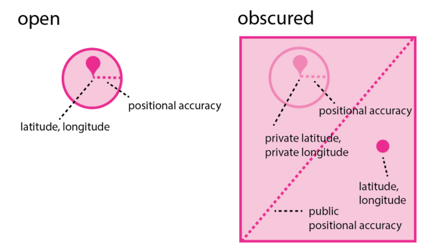
Other information on an observation that may help reveal the true location such as Locality notes and date are also publicly replaced with coarser representations (e.g. ‘Yuba Ave, San Pablo CA, US’ replaced with ‘California, US’ and in some cases ‘June 21, 2021’ replaced with ‘June 2021’). Geographic searches on most places use the publicly blurred latitude and longitude (searches on countries, states, and counties use the private latitude and longitude).
Private: No geographic information is shared publicly. Latitude, Longitude, and Locality Notes are completely hidden from the public (note that the timezone part of the date is still shown). Similarly, observations are ignored by all place-based observation searches (e.g. a private observation located in California would not be returned by a search of observations in California). The private setting should be used sparingly since the complete lack of geographic context makes it difficult or impossible for the community to identify observations or spot geographic data quality issues.
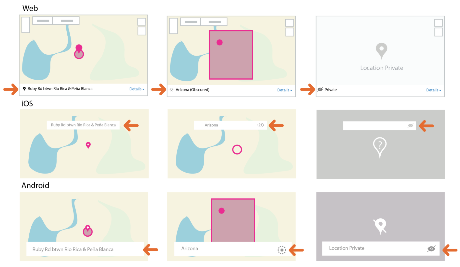
To tell whether you are seeing the true location or an obscured location pay attention to whether you are seeing a stemmed marker (indicating the true location) or a stemless marker (indicating an obscured location). To tell whether the observation is open, obscured or private (independent of what you may be seeing based on your permissions), pay attention to the icons pointed out by the orange arrows below.
Note on mechanics: iNaturalist’s approach to restricting geographic information isn’t perfect. There are ways that the precise location of obscured observations can be guessed. For example:
- Clues in the photos or description: Landmarks visible in an observation’s photo, text in its description, or inclusion in certain projects may reveal clues about the true location.
- Interpolating from nearby observations: If an obscured observation was made at a similar time to an open observation made by the same user, the true location of the obscured observation can be guessed. iNaturalist avoids displaying the exact date of obscured observations publicly but this information is still available in the API responses and nearby observations can be inferred by searches, the observation_id, or even just making guesses about a user’s behavior including the places they frequent. We are working on structural changes to make interpolating locations more difficult, but in the meantime we recommend not posting any open observations nearby in space and time to where your obscured observation was posted.
- Data breaches: While we do our best to protect iNaturalist against data breaches, we can not guarantee that data breaches will never occur.
If the true location of an obscured observation of extreme sensitivity can be guessed through means such as those described above, the observer should be contacted and persuaded to edit or delete the observation. In extremely rare cases, if the observer is unreachable and the nature of the sensitivity is extreme please contact iNaturalist staff who may intervene.
-
When restricted information is shared
Geoprivacy: If you set geoprivacy on your observations there are three ways the restricted location information can be shared with others:
- If you 'trust' an individual
- If you 'trust' a project
- If you join via or affiliate with an iNaturalist Network Node (e.g. iNaturalist Australia)
Taxon Geoprivacy: In addition to the above ways to share, iNaturalist occasionally responds to inquiries from conservation organizations and researchers with exports that include geographic information restricted due to taxon geoprivacy.
-
How do I add sounds?
You can add sounds by dragging wav, mp3, or m4a format sound files into the uploader on iNaturalist. You can also import sounds using the import tool, similar to the uploader. Sound files may added to existing observations as well, via this method. You can also record and/or import sounds via our Android app and record sounds in our iOS app.
-
Can I upload videos to iNaturalist?
Currently, iNaturalist only supports the uploading of still images and sounds. As a workaround you can use a screen grab from your video for the observation's still image, then upload the video to a video hosting site such as Flickr, YouTube, Vimeo, or Google Photos and link to the video in the observation's description.
-
What are tags, observation fields, and annotations?
Tags are keywords you can add to an observation to make them easier to find. For example, if a barracuda followed you on a scuba diving trip in Turks and Caicos, you might tag the observation "scary, barracuda, scuba diving, vacation, turks and caicos".
Annotations and observation fields are other ways to mark observations that work differently. You can read more in this article on Annotations.
-
What does it mean to link iNaturalist to my Flickr account?
iNaturalist can link directly to the Flickr photo service so that you can add your Flickr photos to your observations. When you agree to link your Flickr account, you are simply linking two accounts; we do not have access to your Flickr password and you are not forsaking your copyright nor giving us the ability to use any of your photos in ways that you do not want.
-
Why is my observation not showing up in a Place or Collection project? I know I observed it there.
The most common cause has to do with how iNaturalist indexes observations as being in a place. Each place boundary has what is called a "bounding box," which is a rectangle of latitude/longitude lines that inscribe the entire boundary. For example, below in red is the approximate bounding box for Lake Merritt, in Oakland:

iNaturalist will not index an observation as being in Lake Merritt if either the observation's accuracy circle or obscuration rectangle break that bounding box. We do this to prevent observations from being added to a place when there's a chance they were not found there and, more importantly, to prevent users from narrowing down the location of an obscured observation. This means that if you have a Collection project for a small place, obscured observations as well as observations made near the edge of the boundary may not be displayed in your project and you may want to consider using a traditional project.
Note that this does not apply to counties, states, and countries and their equivalents, which are “standard places” in iNaturalist (as opposed to “community curated places” that anyone can add.
-
Can I upload my old photos as observations?
Yes, as long as you know the correct date and location, it's fine to post older photos. Here's an interview with a user who's posted decades worth of slides from his archive.
-
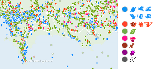
What do the map symbols mean?
We represent observations on maps in two broad ways, to show large quantities of observations on the map at the same time or at coarse zoom levels, we use circles. When showing fine zoom levels, we use "markers," which look like teardrops
 for observations with public coordinates but display as circles
  if the observation location is obscured from the public (see geoprivacy sections above). All observations not marked as captive or as having location issues are mapped.
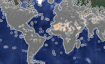
At very fine zoom levels, the grid cells are replaced by individual, clickable points. The colors of the points indicate the branch of the tree of life that the observation represents. A small white point in the center of the marker indicates that observation is Research Grade.
-
Why can't I add observations of rocks or litter? They're part of nature and affect wildlife.
iNaturalist has no plans to expand its functionality beyond its current focus on wild organisms and recent evidence of wild organisms. We recommend using existing platforms such as Rockd and Litterati for posting observations of non-organismal phenomena. Another platform, Anecdata, allows you to create and manage bespoke data collection projects.
-
Why is my observation's location name incorrect?
When you submit an observation, iNaturalist sends the coordinates to Google Maps (for the website and Android app) or Apple Maps (for the iOS app). iNaturalist then displays the name it gets back from the map service, which iNaturalist calls the "Locality notes". These names are not always accurate and serve mainly to provide some context to the location. The important location data in an observation are the coordinates and accuracy circle.
If you're unhappy with the Locality notes provided by Google or Apple, you can edit them from the iNaturalist website or in the Android app. You can also contact Google or Apple to tell them about the error.
-
Why is "iNaturalist" voting that my observation is not "wild"?
iNaturalist will automatically vote "No" in response to the "Organism is wild" metric in the Data Quality Assessment if the following conditions are met for observations of the same taxon in the same tertiary political boundary (e.g. a county in the U.S.):
There are at least 10 observations
80% of those observations are "captive / cultivated"
People post a lot of observations of pets, house plants, and other captive / cultivated organisms, and in places with a lot of observations, this prevents these observations from flooding identifiers with observations that we tolerate but do not encourage. It does come with the cost of some incorrect votes, e.g. escaped garden plants or genera that have a lot of observations of both wild and cultivated plants. If you see this system adding an incorrect vote, you can correct it by voting against it in the Data Quality Assessment.
Identifications
-
What is an identification?
An identification, or ID for short, is an assessment of the type of animal, plant, or other organism that was observed. It is typically listed with a common name and a scientific name, though some species do not have common names. When you make an observation, identify the organism as best as you can, even if that is just “plant” or “bird.”
On iNaturalist, other users are encouraged to add identifications to each other’s observations, based on the evidence provided, in order to confirm or improve the Community Identification (see further discussion below on Research Grade status).
Add identifications at a level that you are confident of and that is supported by the evidence provided in the observation. For example, if based on the evidence in the observation, you think it could be either a Short-tailed Weasel (Mustela erminea) or a Long-tailed Weasel (Mustela frenata), but you're not quite sure or the evidence isn't clear enough, you should add an identification of Weasels (genus Mustela).
There are several types of IDs:
- Leading: Taxon descends from the community taxon. This identification could be leading toward the right answer.
- Improving: First suggestion of this taxon that the community subsequently agreed with. This identification helped refine the community taxon.
- Supporting: Taxon is the same as the community taxon. This identification supports the community ID.
- Maverick: Taxon is not a descendant or ancestor of the community taxon. The community does not agree with this identification.
-
When should I agree with someone else's identification?
An identification confirms that you can confidently identify it yourself compared to any possible lookalikes. Please do not simply “Agree” with an ID that someone else has made without confirming that you understand how to identify that taxon. If you agree with the ID without actually knowing the taxon, it may reach Research Grade erroneously.
-
What if I disagree with someone's identification?
If you disagree with an identification, the best thing to do is to add an identification of your own. It's helpful to provide a reason for disagreement in a comment.
If it is your observation, your ID differs from the community’s assessment, and you prefer that your ID take priority, it is possible to reject the community ID by clicking the "Reject?" link above the community ID. You can also opt-out of community IDs entirely in your account settings. However, note that observations will become Casual grade if the observer has opted out of the community ID and the community ID taxon is not an ancestor or descendant of the taxon associated with the observer's ID.
-
I identified my observation after someone else added a higher-level ID, so why is the observation stuck with the higher-level ID?
That's the way the community ID system works: iNat chooses the taxon with > 2/3 agreement, and if that's impossible, it walks up the taxonomic tree and chooses a taxon everyone agrees with, so if I say it's Canis and you say it's Canis familiaris, 2/2 identifications agree it's in Canis but only 1/2 think it's Canis familiaris so iNat goes with Canis.
If you don't like this and want your ID to take priority for your observation, just reject the community ID by clicking the "Reject" link under the community ID. You can also opt-out of community IDs entirely by editing your settings. You don't need to ask people to remove their higher-level ID, especially if it's accurate (but not precise). This doesn't affect an observation's potential to reach Research Grade status, it just gives the observer control over what taxon the observation is associated with.
-
Why do people keep adding "obvious" IDs like "Plants" or "Fungi"?
This usually happens when you did not add an ID yourself, so your observation is sitting in uncategorized limbo. By adding a coarse ID of "Plants" or "Fungi" these identifiers are making it easier for other people to find your observation. Many experts use our taxonomic filters to focus on their taxon of expertise, so if you post an observation of a plant with no identification, these experts will never find it. People adding coarse IDs are almost always trying to help you get more specific IDs.
-
I don’t agree with iNaturalist’s taxonomy. Do I have to follow it when I add an ID?
As much as possible iNaturalist tries to follow secondary taxonomic authorities, for reasons explained here. We understand that not everyone will agree with the current taxonomy on iNaturalist, but we believe it is important that when you add an identification to an observation, you should follow the taxonomy here. This is important because:
- It ensures we are all talking about the same things. While you may not personally agree with our current definition of Exampelia generica, everyone on iNaturalist will at least understand what is meant by an ID of Exampelia generica.
- When taxonomy is updated, those updates will be correctly reflected in the ID.
- It prevents messy taxonomic arguments on observation pages, where they don’t belong.
So if you don’t want to follow iNaturalist’s taxonomy for a taxon, please refrain from adding an ID for said taxon - you can add a polite comment instead. If you have an issue with any taxon on iNaturalist, you can go to the taxon’s page, click on Curate (under the graph) and select “Flag for curation”. There you can write a note (citing evidence), and the site curators can discuss your proposal.
iNaturalist’s taxonomy is a communally-curated synthesis, and thus no one agrees with all of it. If you can’t accept a taxonomy that you don’t completely agree with, iNaturalist is probably not the place for you, and you should instead consider other data recording platforms.
-
I posted an observation a few days ago but no one has Identified it yet. Am I doing something wrong?
It’s important to remember that all identifications on iNaturalist are made by other users who are all volunteering their time to identify observations; there are no iNaturalist staff members who are paid to add identifications. This means it can take some time for observations to receive identifications. As of early September 2019, the average time it takes for an observation to receive an ID is about 557 hours (a little over 3 weeks). You can check the current number on the Site Stats page. Some observations never receive an ID.
Other factors affecting time to ID are:
- How active the identifier community is in your area. Generally, the more active users there are in a region, the sooner observations there will get identified.
- What type of organism you observed. Birds, reptiles, and amphibians generally get identified more quickly than other taxa. Plants, fungi, insects, spiders, fish, mollusks, and others generally take longer, but this can vary.
- Whether the photos or sounds you uploaded are helpful with identification. In general, it’s best to have close, detailed photos that depict multiple parts of the organism, such as the leaves and flowers of a plant, or the top and bottom of a mushroom cap. Blurry, distant photos are often not useful for identification.
- How “searchable” your observation is. Adding even a coarse ID to an observation, like “Insects” or “Plants” will help users searching for observations of those taxa to find your observation. And because iNaturalist’s focus is on wild organisms, observations of captive/cultivated organisms do not turn up in search results by default, so you’re better off posting wild organisms.
-
What does it mean to mark an observation as "Reviewed"?
By default, the Identify page only shows you observations that you haven't "reviewed," so marking an observation as "reviewed" means you no longer want to see it on the Identify page. Adding an ID to an observation, or marking it as Captive/Cultivated automatically marks the observation as "reviewed," but you can manually mark it if you don't want to see it the next time you use Identify.
Marking an observation as "reviewed" only affects your experience, it does not hide it from other users who are using the Identify page.
-
What if an observation has photos or sounds of multiple different species, like birds, lizards, and flowers?
If you see an observation that has two or more photos depicting different organisms in each, it’s best to identify to the lowest taxonomic level that fits all photos and make a comment politely asking the user to separate the photos into different observations. For example, if the first photo is a flower and the second is a bug (without the flower), identify it as “Life”. If the observation has photos of grass and a rose, identify it as "Flowering plants". If the user is unresponsive to requests to separate the photos, mark the observation as “Based on the evidence, can the Community ID still be confirmed or improved? No, it’s as good as it can be” in the Data Quality Assessment section.
-
What should I do about "duplicate" observations?
Some iNaturalist users, usually inexperienced ones, don't know how to add multiple photos of an organism to one observation and end up making multiple observations from one encounter with an individual organism. And others, either via a mistake or a technical issue, may upload the same photo multiple times for the same organism. While this can be frustrating, it's not a big problem if the user only does it on a few occasions.
If you come across a duplicate observation, please do not flag it or identify it differently. If you want to identify it, add an identification to the most accurate level you can and include a polite comment explaining to the observer that they should make one observation per encounter with an organism and, if possible, remove extraneous observations. This is usually enough to prevent them from doing it in the future.
If a user continues to do this despite being asked stop by the community, please email help@inaturalist.org and we'll take a look.
Taxa
-
How do I add a missing species to the iNaturalist database?
If a species or other taxon is missing from the iNaturalist database, first try clicking the "Search external name providers" link that appears after you search for a name and get no results. You can also try alternative names that we might recognize (common names, old scientific names). If that doesn't work, add the original name to the description or as a comment. Then navigate to the taxon page where the name should appear, such as the genus of the missing species, and click "Curation," then "Flag for curation" on the right side of the page. Leave a short message explaining what needs to be done as well as some information establishing the legitimacy of the name, like links to websites or books that use it.
-
Can I add common names?
You can add common names by going to the Taxonomy tab on a taxon page and clicking "Add a Name", but please abide by the guidelines listed there as well as those listed in the Curator's Guide.
-
Why don’t I see my expected common name?
iNaturalist has a number of settings related to common names, and they are applied in a particular way. This is how iNat determines the common name displayed to you:
First, iNat looks for the default (top-ranked) name that is set to be used in your preferred name place. If you have no place priority set, or there is no name listed for that place, then iNat will use the top-ranked name in your Language/Locale setting. Only curators have access to the page that shows the name rankings and place associations, however anyone can use the API to view this information, e.g. https://www.inaturalist.org/taxon_names.json?taxon_id=55819. If there is no name listed for your Language, then iNat will use the top-ranked Global Name.
Additional notes: when checking for names in your preferred name place, iNat will also check ancestor places, but only if your Language setting matches the language of the common name. For example, if your preferred place is set to Wien, which is a child of Austria, you will see the name for Austria if you are running the site in German.
The languages available in the Language/Locale setting are determined by their site translation status.
If you still aren’t sure why a particular common name already added to iNaturalist isn't displayed for you, raise the issue at the iNaturalist forum or by flagging the taxon. Please include your Language/Locale setting, your preferred place name setting, the taxon, the name you are seeing, and the name you expect to see.
-
Something is wrong with the taxonomy, a species name, or common name. How does this get fixed?
If you notice something wrong with the taxonomy, such as an outdated name, misspelling, or formatting errors, navigate to the taxon page and click "Curation," then "Flag for curation" on the right side of the page. Leave a short message explaining what needs to be done and an iNaturalist curator will look into the issue.
-
The taxon photo is wrong. How does this get fixed?
If you notice a bad taxon photo, you can fix it yourself in most cases. Navigate to the taxon page and click "Curation," then "Edit Photos" on the right side of the page. Use the window that pops up to delete/add photos. If the taxon has locked photos, click "Curation", then "Flag for curation" and leave a message describing the issue.
-
What guidelines should I follow when choosing taxon photos?
As described above, any user can edit a taxon's photos. Taxon photos are the first images people see when they research a taxon, so photos that are helpful for identification should be prioritized. Here are some guidelines for choosing appropriate taxon photos:
- The default (first) photo should be clear and legible even at small sizes because it’s shown in reduced size on observation pages, lists, in the mobile app, and elsewhere.
- Photos should be clear and show diagnostic features of the taxon.
- Photos should show as much morphological and phenological variety required for identification (e.g. life stage, sexual dimorphism, plant phenology) in as few photos as possible.
- Blurry or unclear photos are better than no photos at all. If the only available photos are not clear, it’s fine to use them.
As of February 15th, 2023, changes to taxon photos are now recorded publicly on the taxon’s history page. If there are repeated changes, please flag the taxon and tag the users involved in the changes to have a discussion. Staff may lock a taxon’s photos in the event of an unresolved edit war.
-
A species should be marked as present/absent or native/introduced in a certain place. How does this get fixed?
If you notice something wrong or missing with the nativity or presence status for a species in a certain place, you can flag the species for curation or fix the status on your own. To flag for curation, navigate to the taxon page and click "Curation," then "Flag for curation" on the right side of the page. Leave a short message explaining what needs to be done and an iNaturalist curator will look into the issue. To fix an issue yourself, follow the instructions below.
To change an existing listing, go to the taxon page:
- Click the "Status" tab
- Under "Establishment Means", click "View" next to the place
- Click the edit button next to "Establishment Means", make your changes, and provide a source in the notes, especially if changing an existing status or if it may be a controversial change
- Click Save
To add a new listing, in the main header search:
- Search for the place of interest in the main header search, e.g. the state, country, or other place, then click "About"
- Lefthand side (scroll down)>View check list page
- Search for taxon where it says "Type taxon name"
- If not on list, "Add to list" and add taxon to list
- Once on list, click "Edit" next to the taxon
- Click the edit button next to "Establishment Means", make your changes, and click Save
-
Is there anything more than animals, plants, and fungi? What are all the kingdoms of life?
Yes, there are actually 8 kingdoms of life! A kingdom is the highest category of taxa, so if species are in separate kingdoms they are very, very distantly related.
In addition to animals, plants, and fungi, you've probably also heard of bacteria and viruses. The other three kingdoms are Archaea, Chromista, and Protozoa.
Scientific Name Common Name Animalia Animals Archaea Archaea Bacteria Bacteria Chromista Kelp, Diatoms, and Allies Fungi Fungi Including Lichens Plantae Plants Protozoa Protozoans Viruses Viruses
Computer Vision
-
What is computer vision?
Computer vision is the process of teaching computers to recognize patterns in images. iNaturalist launched its first computer vision demo in April 2017. iNaturalist uses computer vision systems trained on users' photos and identifications in order to provide automated taxon identification suggestions. The model's identification abilities reflect the collective human expertise of the iNaturalist community.
-
Which taxa are included in the computer vision suggestions?
This has changed over time, but as of the model released in March 2020, taxa included in the computer vision training set must have at least 100 observations, at least 50 of which must have a community ID. Photos for training are randomly selected from among the qualifying iNaturalist observations (that is, it is not only the first image of an observation that may be used for training). Related species are sometimes inserted into the suggestions based on being expected nearby. When using computer vision, only the first image is assessed.
As more observations are added and more identifications made, additional taxa can be added to the computer vision suggestions. This means your observations and IDs work to make better models!
-
Why can't computer vision identify my photo correctly?
The computer vision suggestions are most accurate for areas with high activity on iNaturalist, such as North America and New Zealand. It may be that the species you are observing is not yet included in the possible suggestions (see above).
It's also important to remember that the computer vision model is not trained to recognize a certain species—it is trained to recognize typical iNaturalist photos of a certain species. Most photos on iNaturalist are taken with smartphones or other consumer-grade equipment and the organisms are almost always in situ. If you try to use computer vision on pinned insects, for example, it probably won’t work that well because most of the images it has been trained on were of insects observed in the wild.
-
How can I tell if someone selected a computer vision suggestion?
If a user has selected a computer vision suggestion for their identification, a small icon will appear in the upper right of their ID when viewing iNaturalist through a web browser. Clicking the icon reveals additional information about computer vision.
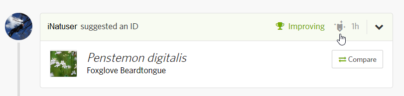
Note: It is not possible to tell whether the user selected a computer vision suggestion because they are following the suggestion versus whether they are simply using the tool as an "autofill" to save time and effort typing out species names.
-
What does "Expected Nearby" mean?
The “Expected Nearby” label on the computer vision suggestions indicates that the iNaturalist Geomodel predicts that the taxon occurs in that location. The About page for each taxon in the model has a link that shows the taxon in context within the Geomodel.
By default, the iNaturalist only displays suggested taxa that are visually similar and are expected nearby (if visually similar taxa are expected nearby). If no visually similar taxa are expected nearby, it displays visually similar taxa regardless of where they are expected to occur.
Science and Research
-
How is iNaturalist data used for research?
iNaturalist observations are used in hundreds of scientific publications. Many of them are using data that is shared with the Global Biodiversity Information Facility as part of the iNaturalist Research-Grade Observations dataset. You can browse the ongoing list of the publications that have cited a GBIF dataset containing at least one record from iNaturalist. Some of the most noteworthy applications of iNaturalist data are highlighted on the Press page.
-
How can I download data from iNaturalist?
Anyone with an account can export data from iNaturalist as a spreadsheet in csv format. You can start from the Explore page and click download in the lower right of the filters box. Or you can go directly to the export page (https://www.inaturalist.org/observations/export).
If you plan to publish a paper using iNaturalist data, we recommend downloading iNaturalist data from the Global Biodiversity Information Facility because they will issue a citable DOI (see below for more details).
-
I am a researcher or working for a governmental agency. How can I access the hidden coordinates of sensitive species?
The best way to do this is to create a traditional project or a collection project (turn on trust for the latter) and persuade observers to join and trust the project. More information on projects can be found on our Managing Projects page. The observer has to join your project and choose one of the “Yes” options for the project curators to access the hidden coordinates
Another method to obtain these coordinates is to have the user trust you, which they can do via the Manage Relationships link on their Account Settings page. If they trust you, you will be able to see all of their private or obscured locations.
Finally, you can work toward making the relevant conservation status not obscure observations of the taxon in question. iNat curators can do this, but we advise them not to do so before consulting with some relevant stakeholders, e.g. observers and identifiers of the taxon or scientists and conservationists with experience with the taxon. If you are that kind of scientist or conservationist, you can work toward making a clear, accessible, authoritative, and persistent statement that the cost of obscuration (e.g. to conservation work) is greater than the potential cost of coordinate disclosure (e.g. poaching). When done, flag the taxon and cite the URL of your published statement, and describe again why you think the taxon should not be obscured on iNat.
If you have permission to view hidden coordinates of an observation in your project, you should be be able to see those when you go to the observation and when you download a CSV file of observations in your project. For the latter, look under the
private_latitudeandprivate_longitudecolumns. -
How should I cite iNaturalist?
First of all, if you are publishing based on a small number of observations (roughly fewer than 10), please be sure to reach out to the original observer(s) on iNaturalist and let them know about the importance of their observation. Be sure to credit them as well as any experts who may have contributed to the identification. Please use the following format for citing individual records: [Observer name]. [year of posting to iNaturalist]. iNaturalist observation: [url for observation]. Accessed on [date of access].
If you just want to cite iNaturalist (to refer to it generally, rather than a specific record or set of data), please use the following: iNaturalist. Available from https://www.inaturalist.org. Accessed [date].
Multiple records
Please cite a GBIF download whenever possible! The easiest way for us to track research using iNaturalist is for you to download and cite a corresponding dataset from the Global Biodiversity Information Facility (GBIF). Once per week, research grade records on iNaturalist that are licensed for re-use are shared with GBIF. If you need additional records from iNaturalist that are not available from GBIF, you can also cite a dataset downloaded directly from iNaturalist. Citing a DOI for a GBIF dataset allows your publication to automatically be added to the count of citations on the iNaturalist Research-Grade Observations Dataset on GBIF.
If you must cite a download directly from iNaturalist rather than one from GBIF, please use this format: iNaturalist community. Observations of [species list] from [geographic area], [country name] observed on/between [date range]. Exported from https://www.inaturalist.org on [date].
Records not on GBIF
If you are writing up specific iNaturalist records that are not represented in GBIF, please include a link to the specific iNaturalist record(s). Such circumstances could be that you are describing a new species and therefore the records would not meet the criteria for inclusion in GBIF. Please use the following format for citing individual records: [Observer name]. [year of posting to iNaturalist]. iNaturalist observation: [url for observation]. Accessed on [date of access].
-
Which iNaturalist observations are exported for GBIF, and how often does this export happen?
Research-grade observations with CC0, CC BY, or CC-BY NC licenses. iNaturalist generates data for GBIF once a week, and we believe they import it once a week. We have no control over when their importation happens, however.
If an observation in GBIF gets changed on iNaturalist (eg it has a different ID, or is no longer Research Grade), that will be reflected in iNaturalist's next GBIF export and the change should eventually be reflected on GBIF.
-
If an observation’s ID or data quality grade changes, will that change be updated on GBIF?
Changes like this will be reflected in presence or absence of the observation in the DwC-A file iNaturalist generates for them. These changes should show up on GBIF when they import that archive.
-
What other sites use iNat data exports?
iNaturalist generates these pre-packaged data exports for the following entities:
Other sites such as CalFlora and GLOBI, among others, pull data from iNaturalist's API.
Lists
-
What are lists?
Lists are simply public lists of taxa (not observations). For example, you could make a list called "My Favorite Turtles" and add all your favorite turtles. There are a number of different kinds of lists, and they behave in different ways.
- List
-
Just a simple list of taxa with no special behavior.
- Dynamic Life List
-
Automatically updates based on your current observations. Everyone on iNat has a default dynamic life list that contains every species that person has observed.
- Project List
-
A project list belongs to a project and lists all the taxa observed by members of that project. Project lists can also be populated manually by the admin of that project, and can be used to restrict project contributions to taxa that are on the list.
- Check List
-
A check list is a list of taxa that occur in a place. Every place has a default check list, and whenever an observation is made within the place's boundaries and it has achieved research-grade status, the species observed will get automatically added to the place's check list.
iNat users can also add additional check lists to places, but these check lists are not automatically updated. They mainly provide a way for people to bring in outside sources of data or just list things based on their own experience.
Projects
-
What are projects?
Projects collect observations under a common purpose. Any iNaturalist user can create a collection project, however you need to have 50 verifiable observations to create a traditional project.
But it is not necessary to create or contribute to a project to enjoy using iNaturalist. Before you decide to create a project, we recommend you spend several weeks or months using iNaturalist and becoming an active member of the community by regularly adding IDs, comments, and observations. You should be familiar with iNaturalist before creating a project. You can read much more about projects here.
-
How do I restrict project contributions to a geographic area?
When you're editing your project you'll see a section called "Observation Requirements." Enter the place that you want the observations to be restricted to under the "Place" section. Only places with boundaries in our database are available.
Observations with obscured coordinates or large accuracy circles might not show up in smaller places, as explained here.
-
How do I restrict project contributions to a geographic area that isn't already in the database?
If you have 50 verifiable observations, you can make your own place! Click "Places" under the "More" tab in the site header, and click "Add a new place" in the lower right. Upload a KML file. Give your place a name, save it, and you should be able to choose it when editing your project.
If you need to create a KML file for a place with a simple boundary, you can use Google Earth to draw the boundary on a map and then export it as a KML.
-
Why can't I add my observation to this project?
If you're unable to add an observation to a project, it is likely a "collection" type project, which is essentially just a filtered search on all observations. Observations are never “in” a collection project; they either meet the project’s requirements and are automatically displayed when the project page is loaded, or they don’t. If you navigate to a collection project's page on our website, you can click on "View Yours" to see which of your observations meet the project's requirements.
You cannot add or delete individual observations from a collection project. However, note that you can always edit the project to tweak its settings. Because a collection project is a just saved observations search, there is no way for you to exclude specific observations from appearing on a collection project’s page. Please see the Managing Projects page for more information.
-
This observation meets the project requirements, why isn't there a link to the project on the observation itself?
If you're sure the observation meets the collection or umbrella project requirements, and you've confirmed that the accuracy circle of the observation's location doesn't break the bounding box of the place, then check to see if the observer has joined your project. The project link and icon will only appear on their applicable observations if they have joined the project.
-
Can I get around the 50 verifiable observations limit for creating a place or a traditional project?
There is no way to get around this restriction, even if you ask us at help@inaturalist.org. It should not take more than a few hours to reach the 50 verifiable observation threshold. Note that you might not be able create a place or a project for about an hour once you reach the threshold. Here's our blog post explaining the motivations behind this restriction.
-
Why do species counts for my umbrella project and its subprojects differ?
Umbrella projects count taxa using a different method than other projects. Umbrella projects count "species", whereas collection and traditional projects count "leaves". You can read more about these two methods here, but in general the "leaves" count will pretty much always result in a higher number.
Guides
-
What are Guides?
Guides allow users to create species lists that can be shared with others. Please note that as of January 2019, the Guides feature is presented "as is"; while we don’t have any plans to delete it, we don’t plan to develop it any further.
 tiwane